15 Best Scenic Lookouts Along the Pacific Coast Highway. There is a stretch of asphalt in California that feels less like a road and more like a living postcard. The Pacific Coast Highway (Highway 1) isn’t just about getting from San Francisco to Los Angeles; it is about the places where you pull over, kill the engine, and just stare.
You are here because you don’t want the crowded selfie spots. You want the 15 Best Scenic Lookouts Along the Pacific Coast Highway the hidden cliffs, the elephant seal hangouts, and the sunrise points that most tourists drive right past.
I’ve driven this route over a dozen times for Hidden Trip USA, and I promise you: The magic isn’t in the destination. It’s in the turnout. Let’s find some epic views.
Why the PCH is a Driver’s Paradise
Let’s be honest. You could fly from LAX to SFO in an hour. But you’d miss the roar of the waves slapping against granite cliffs 200 feet below your window.
The Pacific Coast Highway (PCH) offers 655 miles of raw coastline. But here is the secret: The “best” lookouts aren’t the ones with the biggest parking lots. They are the hidden gravel turnouts that look like someone forgot to pave them.
In this guide, I am sharing my personal map of the 15 Best Scenic Lookouts Along the Pacific Coast Highway. We are going from North to South (Monterey to Malibu), covering rugged cliffs, sandy arches, and forgotten beaches.
Pro Tip: Drive Southbound. You will be on the ocean side of the road. No crossing traffic to pull over.
The Big Sur Giants (Monterey to San Simeon)
Big Sur is the heart of the PCH. The mountains fall into the sea here. Cell service is zero. Gas stations are rare. But the lookouts? They are world class.
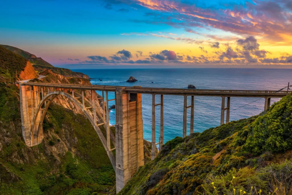
Rocky Creek Bridge Vista Point
Most people stop at the famous Bixby Creek Bridge. Let them have the crowd. You want Rocky Creek.
- Location: Just 3 miles south of Bixby Bridge.
- The View: A concrete bridge arching over a deep, turquoise cove.
- Hidden Tip: Park at the small turnout on the inland side. Walk across the road carefully (watch for fast cars) to the guardrail. Look straight down. On a clear day, you can see sea otters floating in the kelp beds below.
- Best Time: 10:00 AM. The morning fog has usually burned off, but the sun isn’t harsh yet.
McWay Falls Overlook (Julia Pfeiffer Burns State Park)
This is the money shot. A 80-foot waterfall dropping directly onto a pristine beach. You cannot go down to the beach (it’s illegal and dangerous), but the overlook is a 5-minute walk from the parking lot.
- The Catch: Parking fills up by 8:30 AM. Yes, 8:30.
- Hidden Trip Advice: Go at sunset. Most people come here mid day. The sunset casts gold light onto the waterfall. Bring a headlamp for the walk back.
- Cost: $10 entry fee. Worth every penny.
Ragged Point “The Gateway to Big Sur”
Locals call this the “Million Dollar View.” You are standing on a 400-foot cliff. Below you, the Pacific crashes into jagged rocks.
- Amenities: There is actually a hotel and a restaurant here (a lifesaver for bathrooms).
- Hidden Lookout: Do not stop at the main railing. Walk the “Ragged Point Trail” to the left of the hotel for 200 yards. There is a wooden bench no one uses. It faces directly west.
- Wildlife Watch: Whales (December to April) and California Condors (year round).
The “Lost Coast” Lookouts (San Simeon to Morro Bay)
South of Big Sur, the road straightens out. But don’t put the camera away. This area is weird, wild, and windy.
Piedras Blancas Elephant Seal Rookery
Okay, this isn’t a “cliff” lookout, but it is a wildlife lookout. You park, walk the boardwalk, and smell the seals before you see them.
- Why it’s a gem: 17,000 elephant seals fighting, sleeping, and making noises that sound like burping robots.
- Best Months: January (mating season , males fight) and April (weaning pups).
- Photography Tip: Bring a telephoto lens (200mm minimum). You cannot get close, but the seals will put on a show.
- Address: 250 San Simeon Ave, San Simeon, CA 93452. Free parking.
Morro Rock The End of the Line
Morro Bay looks fake. A 576-foot volcanic plug sits right in the harbor. It feels like a movie set.
- The Lookout: Drive to “Morro Rock Beach.” Park in the dirt lot.
- What to do: Walk the jetty. Look back at the town. The contrast between the blue water, the white sand, and the dark rock is insane.
- Hidden Tip: Go during a minus tide. The tide pools on the north side of the rock reveal starfish and anemones.
- Best Time: Late afternoon for golden hour on the rock.
Central Coast Secret Spots (Pismo Beach to Santa Barbara)
Most tourists blow through this section to get to LA. Big mistake. This is where the crowds thin out and the real hidden lookouts live.
Shell Beach – Dinosaur Caves Park
Don’t let the cheesy name fool you. This is a local secret.
- Location: Just north of Pismo Beach. Park at Dinosaur Caves Park (free).
- The View: High grassy bluffs overlooking a protected marine area.
- Hidden Access: Walk the bluffs south for 10 minutes. You will find a wooden staircase (unmarked). Take it down. You land on a private-feeling shelf of rock. No tourists. Just waves.
- Safety: Check the tide chart. Do not go down during high tide or big swell.
Point Buchon Trailhead (Montana de Oro State Park)
This requires a 1.5-mile hike, but you get a lookout with zero road noise. Just wind and birds.
- The Reward: Jagged sea stacks, blowholes (listen for the hissing), and views of Morro Bay from the south.
- Permit Info: You need a free hiking permit from the PG&E kiosk. Get it online the night before.
- Best Time: Weekdays only. Weekends are packed with local hikers.
Gaviota State Park – The Pier View
Most people drive past Gaviota because the highway goes inland for a bit. Don’t.
- The Lookout: Gaviota Pier. It is a rickety old pier that juts out into the ocean.
- Why it’s special: From the end of the pier, look back at the railroad bridge and the tunnel. Trains rumble through the cliffs every hour.
- Hidden Swim Spot: On the south side of the pier is “Gaviota Hot Springs.” A natural hot spring pools in the creek. You can sit in hot water, watching the cold ocean. It’s surreal.
SoCal Iconic Overlooks (Malibu to Santa Monica)
Yes, Malibu is famous. But the famous spots are packed. Let me show you the quieter corners.
Point Dume – The Secret Beach View
Point Dume is a headland that sticks out into the Pacific. The main parking lot is chaos.
- Hidden Lookout: Do not go to the main lot. Instead, park on Cliffside Drive (residential, read the signs carefully). Take the public staircase down to “Little Dume Beach.”
- The View: From the top of the staircase, you look east toward the Santa Monica Bay. On a clear day, you see the Palos Verdes Peninsula.
- Wildlife: Dolphins every single morning. I am not exaggerating. Grab coffee and get there at 7:00 AM.
El Matador State Beach – The Arch Rock
El Matador is famous for a reason. But the hidden lookout is above the beach, not below.
- Location: 32350 Pacific Coast Highway, Malibu.
- The Secret: Park at the top. Before you walk down the 150 stairs to the beach, walk south along the bluff for 30 seconds. There is a dirt path.
- The View: A natural sea arch from the top down. You get the arch, the whitewater, and the sunset all in one frame.
- Cost: $8 parking. Arrive before 9 AM or after 4 PM to avoid the line to get in.
Topanga Overlook (Topanga State Park)
This is the only lookout on this list that doesn’t face the ocean directly. It faces the coastline.
- Why go: You can see the curve of the PCH from Santa Monica to Malibu. It is a “big picture” view.
- Access: Drive up Topanga Canyon Blvd (Highway 27) for 2 miles. Look for a brown gate on your left.
- The Hike: 0.2 miles to the overlook. Easy.
- Best Time: Golden hour. The sun sets behind you, lighting up the entire coastline in orange.
Practical PCH Road Trip Planner
You know the lookouts. Now, how do you hit them all without losing your mind?
Bulletproof Daily Itinerary (3 Days)
- Day 1 (Monterey to Big Sur): Stay in Carmel by the Sea. Hit Rocky Creek, McWay Falls, and Ragged Point. Overnight in Cambria.
- Day 2 (Cambria to Santa Barbara): Piedras Blancas, Morro Rock, Point Buchon, and Gaviota. Overnight in Santa Barbara.
- Day 3 (Santa Barbara to Malibu): Shell Beach, Point Dume, El Matador, Topanga. End in Santa Monica.
The “No-Go” Zone: Road Closures
Critical Update: Highway 1 at Paul’s Slide (near Ragged Point) closes frequently due to mudslides.
- Before you drive: Check “Caltrans District 5 Road Conditions” on Twitter or the Caltrans website.
- The Detour: If the road is closed at Ragged Point, you must turn around and go inland via Highway 101. It adds 2 hours. Do not try to sneak past barriers.
Packing for the Lookouts (Essential Gear)
- Layers: It can be 80°F inland and 55°F at the cliff edge. Bring a windbreaker.
- Binoculars: For whales and seals. You will regret not having them.
- Cash: Many state park parking kiosks are cash only ($8–$15).
- Paper Map: Cell service dies from San Simeon to Carmel. Download offline Google Maps and bring a paper map of Big Sur.
Seasonal Timing for the Best Scenic Lookouts Along the Pacific Coast Highway
When you go changes everything.
- Spring (March–May): Green hills, wildflowers (purple lupine and orange poppies). The lookouts look like a Windows desktop background. Fog is rare.
- Summer (June–August): The worst time for views. June Gloom is real. Morning fog burns off by 1 PM if you are lucky. Crowded. Expensive.
- Fall (September–November): The Goldilocks window. No fog, warm weather, fewer families (school is in session). September is perfection.
- Winter (December–February): Storm watching. This is a different adventure. You go to see 30-foot waves crashing against the rocks. Dangerous, but spectacular. Bring a raincoat.
Hidden Trip Verdict: Go the second week of September.
Photography Secrets for PCH Lookouts
You have an iPhone. I have a Sony Alpha. It doesn’t matter. Here is how to win.
- The Polarizer Filter: If you have a real camera, buy a circular polarizer. It removes the glare off the water. The ocean turns from white to deep blue.
- Golden Hour is a Lie (Sort of): The “Blue Hour” (30 minutes before sunrise) is better. The water is glassy. No wind. No people.
- The Rule of Thirds: Put the horizon on the top third or bottom third of your screen. Never in the middle.
- ND Filter for Waterfalls: For McWay Falls, a Neutral Density filter allows a 2-second shutter speed. The water turns to silk. Very dreamy.
Also Check : Best Small Beach Towns in USA for Couples Hidden Coastal Gems
Where to Eat Near These Lookouts (Because You Get Hungry)
Driving the PCH burns calories. Here is the fuel you need.
- Near Rocky Creek: Nepenthe (Big Sur). Expensive, but the view from the patio is worth the $25 burger. Order the Ambrosia Burger.
- Near Piedras Blancas: Linn’s Easy As Pie Cafe (Cambria). Oliabarry pie. You have never tasted a berry like this. It only grows here.
- Near Morro Rock: The Galley Seafood & Grill. Sit at the counter. Order the clam chowder in a sourdough bowl.
- Near El Matador: Malibu Seafood Fresh Fish Market. Cash only. Order the fried clams and eat them on the picnic benches across the street.
Common Mistakes (And How to Avoid Them)
I have made every mistake so you don’t have to.
- Mistake 1: Trusting your GPS. Fix: GPS will try to route you inland to save 7 minutes. Ignore it. Stay on Highway 1.
- Mistake 2: Driving at night. Fix: Zero lighting, sharp turns, and deer. Do not drive the PCH in the dark. Stop by 5:00 PM.
- Mistake 3: Skipping the “Northbound Look.” Fix: Even though you drive south, look in your rearview mirror. The northbound view (behind you) is sometimes better.
- Mistake 4: Having a full tank of gas. Wait, that’s good. Real mistake: Running out of gas in Big Sur. The closest station is 50 miles apart. Fill up in Monterey or San Luis Obispo.
Frequently Asked Questions (FAQs)
What is the exact address for the Bixby Creek Bridge lookout?
The main turnout is on Highway 1 at Bixby Creek Bridge, Monterey, CA 93940. But for the best photo, park at the small dirt lot just 0.2 miles north of the bridge on the inland side. Walk south along the guardrail.
Is the Pacific Coast Highway currently open all the way?
Not always. As of this writing, check Caltrans Quick Map. The most common closure is at Mud Creek / Paul’s Slide (south of Big Sur). Always verify within 24 hours of your trip.
Can I see the McWay Falls beach from below?
No. The beach is closed to the public to protect the endangered species and due to falling rocks. The overlook is the only legal viewing spot.
Do I need a reservation for parking at Point Dume?
No, but the lot holds only about 50 cars. Arrive before 8:00 AM on weekends. Street parking on Cliffside Drive requires a Malibu resident pass (do not risk the ticket).
What is the best scenic lookout along the Pacific Coast Highway for sunset?
Ragged Point or McWay Falls. Ragged Point offers a direct west view. McWay Falls offers the waterfall reflecting the orange light.
Are these lookouts free?
Most are free if you find street parking. However, Julia Pfeiffer Burns (McWay Falls) costs $10. El Matador costs $8. Piedras Blancas is free. Bring small bills.
How long does it take to drive from San Francisco to Los Angeles via the PCH?
Without stops: 8-9 hours. With stops at the best scenic lookouts along the Pacific Coast Highway: 3 days minimum. Do not rush it.
What should I do if I get car sick?
The PCH is twisty between Carmel and San Simeon. Drive slowly, keep your eyes on the horizon, not on your phone. Ginger chews from any gas station work wonders.
Are dogs allowed at these lookouts?
Generally, yes on paved overlooks. But not on the trails at Point Buchon or the beach at El Matador (no dogs on Malibu beaches except before 9 AM and after 5 PM in winter). Leash required everywhere.
What is the most hidden lookout on this list?
Gaviota Hot Springs / Pier. 90% of drivers blow past it. You will likely have the entire pier to yourself on a weekday morning. It is the true “Hidden Trip” of the PCH.
Conclusion
The 15 Best Scenic Lookouts Along the Pacific Coast Highway aren’t just dots on a map. They are moments. The moment the fog parts and you see a 400-foot drop. The moment an elephant seal sneezes on its neighbor. The moment you realize your phone has no bars, and for once, you are happy about it.
You are not a tourist on this road. You are an explorer.
I hope this guide saves you time, money, and the frustration of parking at the wrong vista point.
Now, I want to hear from you. Have you driven the PCH? Did I miss your secret lookout? Drop a comment below. And if this guide helped you, share it with a friend who needs a road trip.
Drive safe, keep your eyes on the road (not just the view), and leave no trace.